Today we explored an incredible array of natural wonders in the Golden Circle. The Golden Circle is an area of geological marvels just outside of Reyjavik (the furthest part is barely 2 hours by car.) Ninety percent of visitors to Iceland include the Golden Circle in their exploration.
We began in Thingvellir National Park. Thingvellir is not only gorgeous, and geologically significant, but is extremely historically important (and the reason for my comment on the previous post about Naomi’s interest in seeing the Iceland Parliament building.) Iceland actually had the world’s first Parliament! It began in the year 930 and the name of it is pronounced, “All Thing,” which sounds kind of cool to me. Althing means “general meeting” or “assembly” and, other than a few brief periods of takeover by Norwegian or Danish monarchs, has been continuously meeting to decide on the laws of Iceland for nearly 1100 years. While the current Althing meets in the parliament building (included in a slide show in the previous post), the Althing was an open air meeting for most of its first 1,000 years, meeting in what would become Thingvellir National Park. As the population of Iceland grew in the 9th century, they decided they needed an assembly to manage conflicts. Apparently, all those years ago, Thingvellir was chosen for the site of this assembly as it was “centrally located” for the chiefs from all the areas to come in. The longest journey for any chief would have taken only 17 days each way!!! We watched a video about Icelandic history the night before going to Thingvellir and Naomi was fascinated by the Althing. She very much wanted to see the original location and the current one.
Thingvellir National Park is massive, so we decided to do a single hike in it that included a few significant areas and would be about 2 hours round trip. We first got to hike to Oxararfoss (“foss” is Icelandic for waterfall). There are thousands of fosses in the country and each is unique, beautiful, and interesting in its own way. We have seen well over a dozen of them so far, but Oxararfoss was our first one and was beautiful to see. This included a hike in a massive fissure between two canyon walls that was used for the filming of the scene in “Game of Thrones” where Arya Stark and the Hound are traveling to the Eyrie. This hike also….wait for it…is between two tectonic plates, the Eurasian and North American. So yeah, we literally hiked between two tectonic plates, y’all! We then hiked further to the Silfra fissure. While we could not go snorkeling here, as you had to be with a group and there was an age minimum, we did see others snorkeling here. This fissure is also between the tectonic plates, so many come to snorkel in between the continents! Thingvellir was a wonderful introduction to Icelandic nature and hiking…the first baby step of our rapid interactive education in beauty, wildness, and challenge in Icelandic nature over the next few weeks.
Side note: many of the places in Thingvellir are named after the punishment’s the Althing meted out. The names, once translated, are pretty gruesome in many cases!


After leaving Thingvellir, we took a quick drive to Bruarfoss. Thank you, again, to my friend Joanna for this recommendation. We did not have this on our list until she mentioned it to me after her week in Iceland. This gorgeous waterfall is bright icy blue! The Bruara River, upon which Bruarafoss lies, was created by melt from the Langjokull Glacier. The water in this river has a high concentration of glacial sediment and silt, which reflects only green and blue light back to our eyes. It was absolutely gorgeous. We also found a funny food truck in the parking lot and tried our first Icelandic hot dog (take that airport hot dog person!)


Bellies full of Icelandic hot dog (which traditionally comes with ketchup, mustard, remoulade, raw onions, and crispy fried onions), we went on the Geysir. This was our first interaction with the massive geothermal activity in Iceland. This area, Geysir, is actually where the word “geyser” first came from. There are a massive amount of geothermal vents and geysers in this particular area (though this is also true in other parts of Iceland.) You can see quite a few examples of geothermal activity on a very short walk including natural steam vents in the earth, boiling hot pools (literally boiling…you cannot safely touch them), and a large geyser that erupts every 5-10 minutes. These are all different variations of the same phenomenon of water under the earth being super heated and, depending on the particular geological features of that area, creating an enormous amount of pressure that needs to be released. These were all amazing to see and we stayed to see the eruption of the largest geyser, Stokkur, 5 times. Its eruptions are quite varied in height and intensity and we even got to see a double eruption (that Valerie captured on video!)


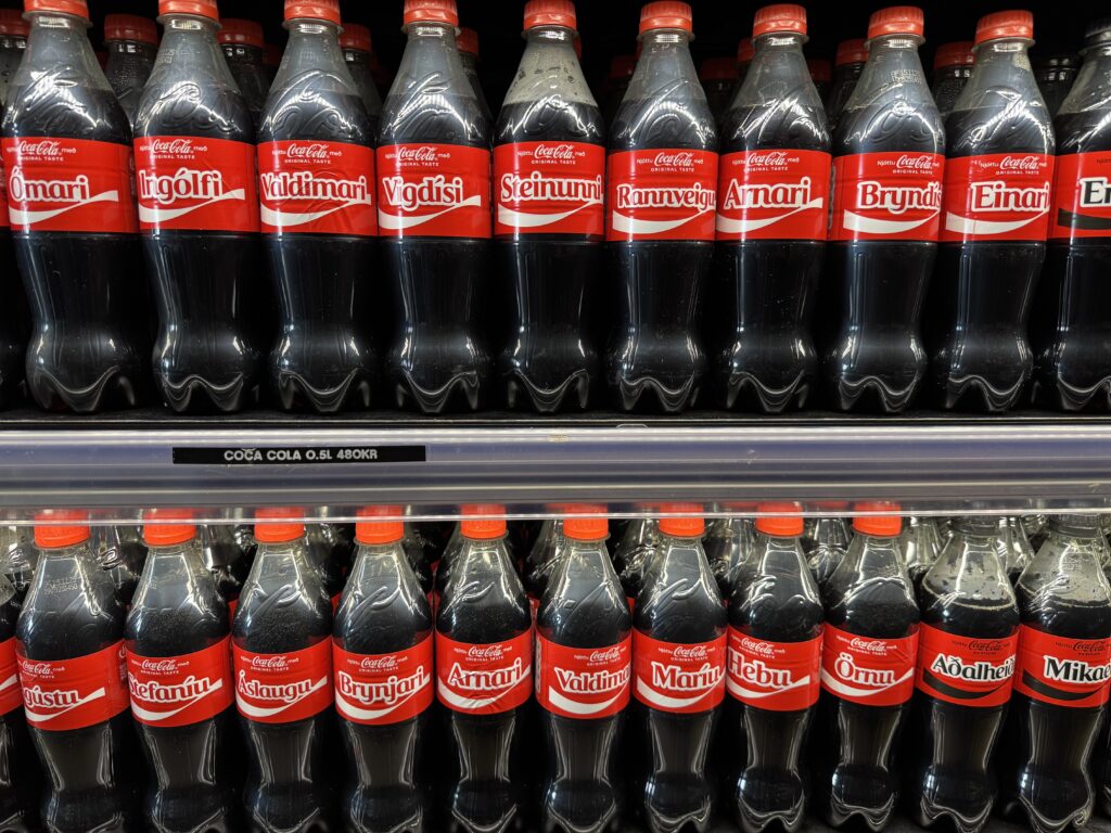
Upon finishing our exploration of this area, we went into the gift shop and restaurant nearby to use the restrooms before continuing our drive. We noticed that, in Iceland, Coca-Cola does the same promotion (putting people’s names on its bottles) as it does in the US, but with Icelandic names. We got a kick out of reading them 🙂
Next, we went to Gulfoss, a massive water fall. It was gorgeous. It was so large and powerful that the mist generated by the crashing water covers the bottom so you cannot see the river below. The mist often also creates rainbows if it is a sunny day. Besides the beauty of this majestic and grand falls, the story of its protection was also quite cool and revealed to us the woman who proved to be Iceland’s first known environmental activist. At one point, the land around Gulfoss was privately owned. It was very difficult to get to. Many people started taking interest in the falls and Sigridur, the daughter of the landowner/farmer would give people tours of the area (and, in fact, created the first path to give people a view of the falls.) Around the beginning of the 20th century, interest in harnessing the power of Gulfoss for hydroelectric power increased. Sigridir and her father were very much against this, but her father was tricked into leasing the land. They fought and fought in the courts, but lost. Sigridir, however, did not stop the fight to save the falls from the environmental degradation that would come to it if used for hydroelectric power. She fought,and traveled, and conversed, and educated, and even threatened to throw herself over the falls if it wasn’t protected. Although Sigridir died in 1957 at 87 years old, her battle was eventually won. Gulfoss was made a protected area and saved for all to enjoy!


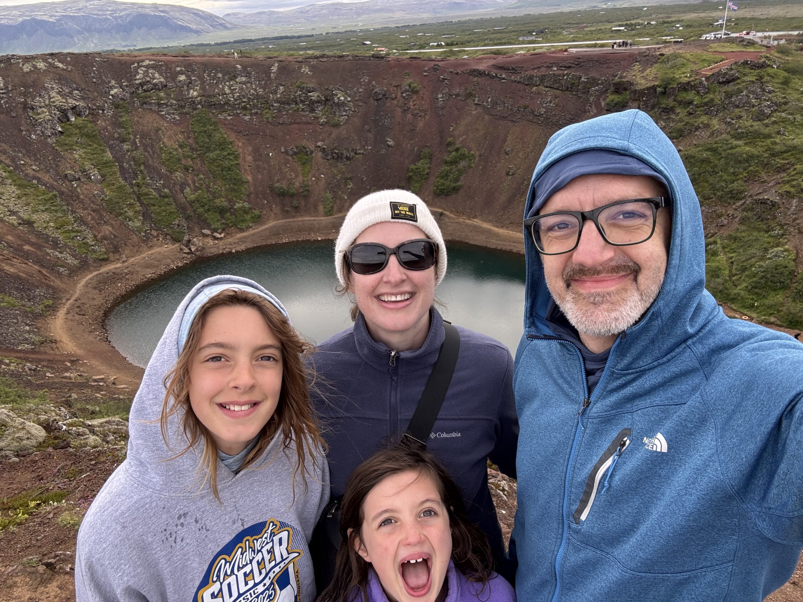
Our final adventure for the day was an exploration of Kerid Crater. Kerid Crater was formed after a volcano’s eruption that caused the top of the volcano to collapse into itself and completely fill the magma chamber of the volcano. The incredibly beautiful blue lake inside the crater is not rain water as is commonly and mistakenly thought, but rather comes from the ground at the level of the local water table. We hiked up the volcano, around its rim, and down into the crater, where we relaxed and the kids through rocks into the lake.


What a busy and beautiful day it was!
July 4, 2025 – Total Step Count 19,816 (Moderate Hills)
PS – Ezra, very organically, made a poster for our “Going Away/Henry Graduation Party” in NJ. It so perfectly summed up our adventure as we Travel Neverland, that it is going to become my tag line/sign off on each post from now on. Stay tuned for the next post to see the unveiling!